|
|
| Home | Milieu & Energie | Gezondheid & Wetenschap | Duurzaam Bouwen | Photo Gallery |
| Geologie & Reizen | Landbouw & Voeding | Natuurbescherming | Eilanden | Geo-educatie |
|
Islands: |
|
Malta & Gozo in 4 days Go to travel report >> |
|
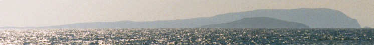
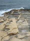
Summary: More than one island in the Mediterranean claims to be the 'Island of Calypso'. One of them is Gozo, the neighbour of Malta and part of Malta as a country. Both islands are of great interest. The abundancy of churches, the agricultural landscape of Gozo, the harbour of Malta, the chance to hop to Sicily to see mount Etna in one day, megalithic temples and ancient salt pans. Three islands make up the Maltese archipelago: Malta, Gozo and Comino. This Mediterranean island group lies at a latitude of 36 degrees North and a longitude of 14 East. On the photograph, you can see salt pans that are still beautifully intact which once were carved from the limestone, near Il-Blata I-Bajda in the middle North of Malta. Photograph: A. van Roekel |
|
Scotland in 4 days Go to travel report >> |
|
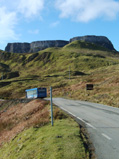
Summary: This description of a short trip to the Scottish Isle of Skye by
the West Highland Line offers you an educational trip in this beautiful part of Europe. If your
spare time is scarce and you still are keen on seeing the world, this trip description might
be useful to you. The roundtrip starts in one of the Scottish cities and takes you along the
famous railway to Malaig and next to the Isle of Skye. It offers you some geological and geographical
information from sources that you might only find once you have reached your destination. We took the following route: Edinburgh; Glasgow; Fort William; Malaig; Portree (Isle of Skye) and back the same route. Photo by Annemieke van Roekel: Quirang Rocks, Isle of Skye |
|
Gavdos in 4 days Go to travel report >> |
|
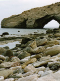
Summary: Take a photographic tour around the island of Gavdos, 26 nautical miles south of Crete at 35N/24E. This unique place in Europe is the southernmost extension of the South Aegean Island Arc and the southernmost piece of European land in the Mediterranean Sea. The northern part of the island has its roots in the middle Miocene (from 16-12 million years ago); the limestone series in the southern part date from the late Cretaceous (100-65 million years ago). The world during the late Cretaceous looked very different from today. It's hard to imagine that the Mediterranean as we know it today did not exist at all. Instead, Africa and Eurasia were divided by the Tethys Ocean. Photo of Europe's most southern rock by A. van Roekel |
|
Vogelparadijs Selvagens In: EOS Magazine, maart 2006  Download pdf >>
1,4 mb Download pdf >>
1,4 mb |
|
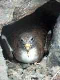
Summary: The Portuguese archipelago, Ilhas Selvagens, in between Madeira and the Canary Islands, is a paradise for more then 100.000 pelagic birds such as the Cory's Shearwater and the White-faced Storm-petrel. The Selvagens constitute Portugal's most southern territory (30N/16W) and belong to Macaronesia, the volcanic islands in the North Atlantic at low latitude. Total land area of the archipelago (S.Grande, S.Pequena and Ilhéu de Fora) covers less than 3 square kilometers. The Selvagens belong to the Nature 2000 network. Interviews with ornithologist Frank Zino and Isabel Fagundes, director SPEA-Madeira. Photo by Isabel Fagundes: Breeding Cory's Shearwater. Read more about the Cory's Shearwater on the Canary Islands >> |
|
Zeewater uit de kraan In: Natuurwetenschap & Techniek, oktober 2005 Download pdf >> 1,5 mb
|
Summary: For many islands, desalination of seawater seems the solution for scarcity of drinking water. But many islands should use their rainwater instead and optimise the use of groundwater, say the Dutch Acacia Instituut and the Ecological Management Foundation. Therefore, traditional systems for storage of groundwater should be redeveloped. This could also help reaching the United Nations Millennium Goals to reduce the population suffering from lack of clean drinking water. On Bonaire, only one procent of the yearly rainfall is sufficient for the needs of the islanders, even to provide agriculture, now a scarce practice on the island. |
|
Aziatische ramp, Canarische tijdbom In: EOS Magazine, februari 2005 Download pdf >> 863 kb
|
|
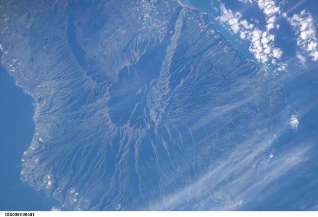
Summary: When the volcano Cumbre Vieja on the Canary island La Palma collapses, there is a real chance that countries surrounding the Atlantic Ocean will experience a tsunami.
Waves as high as ten meters might flood African and European countries and the eastern coast of the United States.
The American geophysicist Steven N. Ward and British volcanologist Bill McGuire think there is a fair chance this will happen in our lifetime. Click on the satellite photo for a close-up of the Cumbre Vieja. Photo by NASA. |
|
De Kreta-crash In: Natuurwetenschap & Techniek, februari 2005 Download pdf >> 1,9 mb
|
Summary: The Mediterranean Sea will disappear in seven million years. Geologists expect that the Greek island of Crete will be the first piece of the European continent to crash with Africa. Subduction of the African plate happens with a speed of four centimeters every year. Forces behind the relatively quick movement of Crete towards Libya are a combination of a push from the Anatolian microplate (Turkey) and a pulling force as a result of the sinking African plate. Utrecht University studies the subduction process and volcanism in this area with new technologies. |
|
Biologische teelt op een vulkanisch eiland In: Ekoland, juli/aug. 2002 Download pdf >> 1,5 mb
|
|
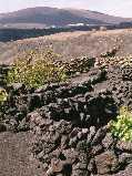
Summary: All seven Canarian islands are volcanic in origin.
But only on Lanzarote the volcanic character is clearly visible in the agricultural landscape.
Organic and regular farmers cover the soil with a layer of volcanic ash to prevent evaporation.
Rainfall is very scarce on Lanzarote and agriculture has been set aside by the ever growing tourist business.
The famous artist César Manrique found most of his inspiration in the lava-landscape of Lanzarote. Photo by Annemieke van Roekel: Vineyards in the area of Geria |
|
Autonoom op een Grieks eiland In: Mens & Wetenschap, november 1999 Download pdf >>
281 kb
|
Summary: On the Greek island Gavdos, located south of Crete in the Libyan sea, a 20 kwatt solar energy plant was built. The project has been financed by the European Union to improve the living conditions of the local people. In remote areas, solar energy is an alternative for the production of electricity by generators using fossil fuels. On Gavdos, solar water heaters are very common. Read more about solar energy on this website >> |
|
De Azoren: leven van vulkanen In: EOS Magazine, oktober 1998 Download pdf >> 884 kb
|
|
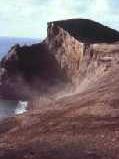
Summary: Unlike the breathtaking volcanic landscape of the Canary island Lanzarote,
the Azores archipelago does not yet have a status of nature protection.
This is a big mistake, says the Portuguese volcanologist Victor Hugo Forjaz.
Forjaz was still a boy when he experienced the last outburst on the Azores in 1957/1958,
when Vulcăo dos Capelinhos enlarged the island of Fayal. Photo by Annemieke van Roekel. Photo serie Volcanoes Azores >> |
|
© Annemieke van Roekel. Niets van deze website mag worden
vermenigvuldigd of openbaar gemaakt door middel van druk, microfilm, fotokopie,
plaatsing van teksten en/of afbeeldingen op andere websites of op welke wijze
dan ook zonder voorafgaande schriftelijke toestemming van de auteur en de
betreffende tijdschriftredacties.
[home] [top] [contact] [disclaimer] |