|
Home
Page 1/6 (this page)
Page 2/6
Page 3/6
Page 4/6
Page 5/6
Page 6/6
|
El Hierro, the youngest Canary.
Island of landslides
webpage 1/6
Text: Annemieke van Roekel, geoscience journalist
www.vuurberg.nl.
This article was first published in Gea Magazine (September 2022).
El Hierro, the most southwestern island of the Canary Archipelago, is covered with many cinder
cones and other young volcanic sediments. Its distinct three-armed island structure is determined
by the structure of rift zones
combined with the collapse of the flanks of the three ridges.
Recent volcanism has made it a beautiful Geopark, with extensive areas of malpaís,
rope lava and cinder cones covered by the Canary Island pine (Pinus canariensis).
El Hierro is the top of a volcanic structure that rises 5.5 km from the Atlantic Ocean floor and
rises 1.5 km above water. What we see is just the tip of the iceberg. As a result of
major landslides, extensive debris fans (aprons) lie all around the island (Fig. 1), with an estimated volume
of three times the current section above sea level.
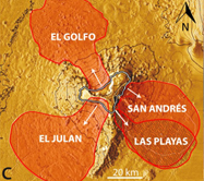
Fig. 1. Debris avalanche deposits on the sea-floor, as a result of lateral collapses off the flanks.
Carracedo & Troll, 2016 (fig. 2.9C). With kind permission.
El Golfo
The last landslide in the Canary Islands was about 15,000 years ago, possibly below sea level,
at El Golfo, in northwestern El Hierro (Masson 1996).
But the first major landslide in El Golfo occurred much earlier,
probably around 130,000 years ago, when the northern ridge collapsed.
Both landslides occurred during a period with sea levels one hundred meters lower than today,
during an ice age.
Since its subaerial existence, 1.12 million years ago, four major landslides
have occurred on El Hierro, and these have largely determined the three-armed shape
of the island. Intrusions of dikes have contributed to the instability
of the flanks (Carracedo et al., 2016). The three-armed geometry is also the basic structure of La Palma
and Tenerife, but on El Hierro the shape is more pronounced due to the young age of the island and
the collapse of the flanks on all three sides.
It wasn't until 1972 that Hausen interpreted the 'crater' of El Golfo (Fig. 2)
as the result of a mega-landslide, at that time without the knowledge
of submarine debris fans. Before then, people thought of a real crater created by a
volcanic eruption, succeeding the theory of fluvial erosion.
Modern techniques with sonar data (Fig. 3) of offshore areas, and to a lesser extent
seismicity, provided definitive evidence of large-scale prehistoric landslides on El
Hierro and the other islands. Of all four major landslides on El Hierro, that of El Golfo is
the most visible and accessible.
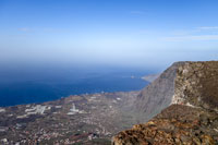
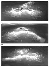
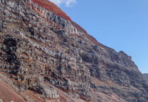
Fig. 2 (left). El Golfo 'crater' (Frontera), with Roques de Salmor at the horizon. The tiny rock are famous
for the (extinct) Hierro Giant Lizard. Fig. 3 (right). Bathymetry mapped
with sonar from three directions: north (top), west (center) and south (bottom). Seabed data
are important to reconstruct and date landslides. Avalanche deposits from El Golfo
have been observed up to 65 km from the coast. Image: CIMA / Instituto Español de Oceanografía.
Page 1/6
Page 2/6
Page 3/6
Page 4/6
Page 5/6
Page 6/6
Copyright: Annemieke van Roekel
Last update: 28 December, 2022
|