|
Home
Page 1/6
Page 2/6 (this page)
Page 3/6
Page 4/6
Page 5/6
Page 6/6
|
El Hierro, the youngest Canary.
Island of landslides
webpage 2/6
Text: Annemieke van Roekel, geoscience journalist
www.vuurberg.nl.
This article was first published in Gea Magazine (September 2022).
Abrasion platform
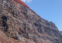
In the 'crater' of El Golfo, largely within the boundary of an ancient abrasion platform,
an active agricultural economy has established itself, of mostly large banana and pineapple plantations, 'wrapped up' in plastic.
Mangoes and grapes are also grown there. Because of the slight differences in altitude,
you can cycle well there (although an e-bike is recommended).
Originally the plain of El Golfo (with the town of Frontera) consisted
of malpaís ('bad land'). To make it suitable for agriculture,
soil and lapilli were moved from the fertile central part of the island, such as from the Meseta
de Nisdafe plateau.
The abrasion platform was formed as a result of multiple landslides and new eruptions
between 100,000 and 50,000 years ago. The sea level then was between 40 and 100 m lower than today.
The submerged part becomes visible during strong NW winds when
powerful waves roll and break over the low-lying platform like a
foaming avalanche (Fig. 4), eventually pounding against a raised edge of basalt columns.
From the slowness of the waves you can tell the enormous dimensions of the below-sea-level
abrasion platform.
Here, natural pools have formed along the coastline
through erosion, where swimmers can descend via ladders into oases of water.
The boundary of a higher platform lies far inland, several hundred meters from the shoreline.
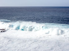
Fig.4. Waves more than five meters high break on the paleo-abrasion platform. The boundaries from
the platform to the deeper parts are formed in many places by basalt columns, created during recent eruptions.
Photo: Annemieke van Roekel.
Fall-winds and calima
El Golfo has a milder climate than the rest of the island: it is less cold in winter and
less hot in summer. However, it is not advisable to stay on this side of the island
between November and February, as it is often stormy; the powerful gusts associated with the surest,
and the fall winds near to the cliff make it unsafe to walk or cycle
on the streets. On top of that, there is sometimes a lot of dust in the air,
either from local sources or from the Sahara (the Calima).
The pronounced three-armed geometry of El Hierro corresponds to the three rift zones,
each forming a 120-degree angle with each other (Fig. 5).
The three ridges continue submarine, the southern one up to 40 km offshore.
Although eruptions have been rare on the mainland in recent and historical times,
they are suspected to have occurred below sea level (Carracedo et al., 2015).
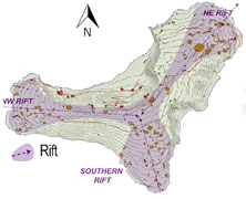
Fig. 5. Recent rift zones and cones. Source: Carracedo & Troll, 2016 (fig. 2.9A). With kind permission.
Page 1/6
Page 2/6
Page 3/6
Page 4/6
Page 5/6
Page 6/6
Copyright: Annemieke van Roekel
Last update: December 28, 2022
|