|
Home
Page 1/6 (this page)
Page 2/6
Page 3/6
Page 4/6
Page 5/6
Page 6/6

|
Porto Santo, safe harbor
thanks to ice age sand
webpage 1/6
Text: Annemieke van Roekel, geoscience journalist
More articles: www.vuurberg.nl.
This article was first published in Gea Magazine
(June 2021). Many thanks to Kellin Defiel for improving the English translation.
The skyline is impressive, however, approaching Porto Santo doesn't make the view more spectacular.
In terms of color and shape, the main island (itself surrounded by a collection of rocky islands)
even looks a bit boring. Fortunately, the geology makes up for it: the variation in peaks turns out to be
a colorful collection of eroded volcanoes.
Porto Santo (33 N, 16 W) is 45 km northeast of Madeira, 2.5 hours by boat from the capital Funchal.
The position of Porto Santo to the NE, as the earth's crust moves in
a northeasterly direction, with an average speed of about 1.5 cm per year, lies over a still active hotspot.
Porto Santo is therefore many millions of years
older than Madeira, where the oldest rocks are dated at "only" 5.2 million years.
Volcano Skeletons
The distinctive skyline of Porto Santo is defined by the skeletons of volcanoes:
the interior and most erosion-resistant part of Miocene volcanic complexes. The island formed
submarine during the Early and Middle Miocene (starting 19 million years ago), followed by subaerial
volcanism during the Middle and Late Miocene (starting 14 million years ago)
(Ferreira et al., 1988). From 10 million years ago, the volcanic activity was limited to the formation
of a few dykes, which define the present landscape, such as the Pico do Facho (fig. 1),
because the softer rock around the dykes has eroded away.
Volcanism ended 8 million years ago.
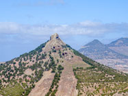
Fig. 1. The picos on Porto Santo are vertical dykes. From left to right: Pico Ana Ferreira,
Pico do Castelo and the highest peak, Pico do Facho (507 m). © A. van Roekel.
Due to later uplift, there are relatively many submarine volcanic deposits;
also during the 'island phase' submarine volcanism continued.
Of all the islands in this part of the Atlantic, this area has the oldest
fossil coral reefs, dating back to 19-14 million years. Vertical tectonic movements
of the ocean floor, rising volcanic cones and tilt have determined the present shape of the
volcanic complexes (Ferreira et al., 1988).
Page 1/6
Page 2/6
Page 3/6
Page 4/6
Page 5/6
Page 6/6
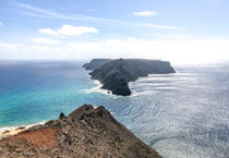
Top photo: View to Ilhéu de Baixo from Miradouro das Flores.
© A. van Roekel
Copyright: Annemieke van Roekel
Last update: July 25, 2022
|