|
Home
Page 1/6
Page 2/6
Page 3/6
Page 4/6 (this page)
Page 5/6
Page 6/6

|
Porto Santo, safe harbor
thanks to ice age sand
webpage 4/6
Text: Annemieke van Roekel
The sands of Porto Santo
These dunes in turn have been the source of the sand deposits on the south coast of the island, containing
fragments of shells, corals and calcareous algae. It has ended up on the entire
south side of the island via rainwater runoff. For a volcanic island, the presence of this 9 km long sandy
beach along almost the entire south coast is unique. The sandy beach is a popular tourist destination and
used to be a well-known place for "sand therapy".
I took some sand samples for the GEA Working Group Sand on the beach of
Porto Santo. Ap Bernhart, who took some photographs,
explains: "The sand grains have a mixed
crystalline and biogenic composition. The erosion is the same
in all samples and most of the grains even have a polished appearance,
which is a result of the strong waves and surf. In the sand sample in fig. 6, the
ratio of light-colored and dark-colored grains is
almost fifty-fifty; compared to the other samples, there are more dark lava-grains.
Since volcanic material has a higher weight than the rest of the material, it takes
more force to deposit it on the beach. A weaker reflux wave no longer has the strength to
take it back."
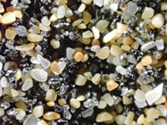
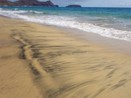
Fig. 6. Sand sample. Photo: Ap Bernhart. Fig. 7. Concentrated patches of heavy sand grains are called placers.
Photo: A. van Roekel.
The heavier minerals often remain as dark spots or stripes on the beach, so-called 'placers'; these
are secondary deposits of concentrated heavier minerals, often presented in beautiful, striking patterns (fig. 7).
In ancient times, the sandy beach was a place where ships could easily anchor,
which is one reason why the island was frequently attacked by pirates. The inhabitants
then fled to the northern part, which is the oldest part of Porto Santo in geology (fig. 8 and 9).
Especially on the north side, because of the dominant north winds, the island is surrounded
by a 50-100 meters deep abrasion platform, which formed up to 18,000 years ago, also the
source of the aforementioned sedimentary deposits (Ribeiro et al., 2010). The sea level was
then 130 meters lower than it is now. For Porto Santo this meant that the area above sea level
must have been five times larger than the current area of 42 square kilometres.
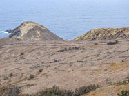
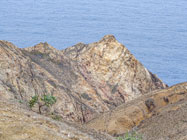
Fig. 8 and 9. The oldest rocks, formed during the submarine stage, are in the northern part of the island. Photo's: A. van Roekel.
Page 1/6
Page 2/6
Page 3/6
Page 4/6
Page 5/6
Page 6/6
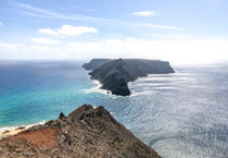
Top photo: View to Ilhéu de Baixo from Miradouro das Flores.
© A. van Roekel
Copyright: Annemieke van Roekel
Last update: July 16, 2022
|