|
Home
Page 1/6
Page 2/6
Page 3/6 (this page)
Page 4/6
Page 5/6
Page 6/6

|
Porto Santo, safe harbor
thanks to ice age sand
webpage 3/6
Text: Annemieke van Roekel
An ocean of seamounts
Between Madeira and Porto Santo, the ocean is more than 2 km deeper than between Madeira and
the Desertas. There is no direct geological relationship; both islands (located on a
140-million-year-old ocean crust) shifted over the same hotspot, which became active more
than 70 million years ago and is responsible for an almost 1000 km long chain of seamounts
in a NE direction, up to the Serra de Monchique on the mainland Portugal. The hotspot
created the seamounts Seine (22 my), Ampère (31 my), Coral
Patch (31 my) and Ormonde (67-65 my), possibly the oldest volcanic complex of this range
in the western part of the Algarve.
The still active hotspot is probably currently located under a seamount southwest of Madeira,
which is 500 m below sea level (Geldmacher 2000). Located on a vast submarine plateau, Porto Santo is much older than Madeira, so erosion has
had a much greater impact on the formation of the present landscape.
The Aeolianites of Fonte da Areia
Around Porto Santo, a vast limestone platform developed in the tropical waters from the Miocene onwards.
When sea levels dropped sharply during the Pleistocene ice ages, the limestone platform dried up. The limestone
grains, a result of erosion, were transported by the predominantly northerly winds to the central part
of the island, at Fonte da Areia, as petrified dunes (eolianites) (Fig. 7).
The sand deposits are up to tens of meters thick, with fossils of snails and plant roots (fig. 8); they thrived
in a more humid climate, about 30,000 years ago.
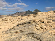
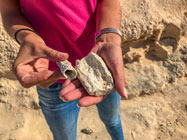
Fig. 4. Eolianites at Fonte da Areia. Fig. 5. Fossils of organisms that lived
here
during humid times. Photo's: A. van Roekel.
Victorian scientists
The dune formations at Fonte da Areia were the subject of study among
19th century geologists and naturalists. During the Victorian era, Madeira was a
favorite place for British and other Western Europeans to hibernate, with or without a doctor's note, and
Porto Santo was also visited. Old photos show how visitors are carried from boats to the beach on the backs
of islanders, to keep their feet dry.
The dune formations were first dated in 1864 by Hartung, under the influence of the famous geologist Lyell,
at Plio-Pleistocene age (Mitchell-Thomé, 1976). Later it turned out that local snail
fossils were not extinct, and Hartung redated the sediments to Quaternary age.
Page 1/6
Page 2/6
Page 3/6
Page 4/6
Page 5/6
Page 6/6
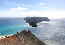
Top photo: View to Ilhéu de Baixo from Miradouro das Flores.
© A. van Roekel
Copyright: Annemieke van Roekel
Last update: July 25, 2022
|