|
Home
Page 1/6
Page 2/6
Page 3/6
Page 4/6
Page 5/6
Page 6/6 (this page)

|
Porto Santo, safe harbor
thanks to ice age sand
webpage 6/6
Text: Annemieke van Roekel
Colorful Morenos
Also on the western tip of Morenos you can admire a colorful
spectacle of pyroclastic sediments (Fig. 13). Along the steep coast, volcanic
rocks from both submarine and subaerial periods are visible, intersected by dykes
of basalt and trachyte, sometimes columnar (Fig. 14). Dykes made up of hard
rock protect the cliffs that are made up of pyroclastic sediments
from rapid erosion (Ribeiro et al., 2010).
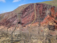
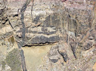
Fig. 13. Pyroclastic rocks cut by dykes. Fig. 14. Detail: basalt columns.
Photos: A. van Roekel.
Sustainable roofs
The roof covering of the traditional houses on the island is truly sustainable: a layer of
bentonite, which makes the roofs waterproof. Bentonite is a submarine volcanic
ash (tuff) that has been weathered to clay. It is locally mined in the
mountains in the vicinity of Serra de Dentro (Fig. 15). After periods of heavy rain,
the bentonite must be reapplied. It is applied on new houses as well (Fig. 16).
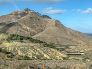
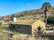
Fig. 15. bentonite is locally available in the mountains. Fig. 16.
Bentonite is a natural material and used for making the roofs waterproof.
Photos: A. van Roekel.
Porto Santo is a surprise for geologically interested people.
The geological phenomena mentioned in this article can be seen at a short distance from each other and are
easily accessible. Porto Santo is an easy day trip from Madeira, but
more than one day to explore this island is of course recommended.
An extensive overview of Geosites (with explanations in English) can be consulted
on this webpageof
the government of Madeira.
References and more reading (complete in the original Dutch article)
- Baarli et al. (2013). A Middle Miocene carbonate embankment on an active
volcanic slope: Ilhéu de Baixo, Madeira Archipelago, Eastern Atlantic. Geological
Journal, 49, 90-106.
- Michael Czajkowski, Nottingham University, Excursion guide 15. A geological tour
of the islands of Madeira and Porto Santo, Blackwell Science Ltd, Geology Today, Vol.
18, No. 1, 2002.
- Ferreira, M.P. et al. (1988). K-Ar geochronology in the Selvagens,
Porto Santo and Madeira islands (Eastern Central Atlantic): A 30 m.y. spectrum of submarine
and subaerial volcanism. Lunar Planetary Institute Abstracts 19, 325-326.
- Ferreira, M.R. (2014). Património Geológico da Ilha do Porto Santo e Ilhéus Adjacentes
(Madeira): Inventariação, Avaliação e Valorização como Contributo
para a Geoconservação.
Dissertação de Mestrado em Vulcanologia e Riscos Geológicos. Departamento de Geociências
da Universidade dos Açores. In: https://geodiversidade.madeira.gov.pt.
- Geldmacher et al. (2000). The 40Ar/39Ar
age dating of the Madeira Archipelago and hotspot track (eastern North Atlantic). Geochem.
Geophys. Geosyst. 1, GQ000018.
- Mitchell-Thomé, R.C. (1976). Geology of the Middle Atlantic Islands. Stuttgart: Borntraeger,
Beitr. Reg. Geol. Erde, Vol. 12.
- Ramalho, R.S. et al. (2015). The emergence of volcanic oceanic islands on a slow-moving plate:
The example of Madeira Island, NE Atlantic, Geochem. Geophys. Geosyst., American Geophysical Union, 16, doi:10.1002/2014GC005657.
- Região Autónoma da Madeira (2013). As Ilhas Desertas (bilingual).
Read online.
- Ribeiro, M.L. et al. (2010). A Geological tour of the
Archipelago of Madeira, Main geo-touristic sites. Direcção Regional do Comércio,
Indüstria e Energia Laboratório Nacional de Energia e Geologia, I.P. Lissabon, 2010.
- Wyse Jackson, Patrick N. (ed.) (2007). Global peregrinations: four centuries of
geological travel. Geological Society,
London, Special Publications, 287, https://doi.org/10.1144/SP287.1.
Page 1/6
Page 2/6
Page 3/6
Page 4/6
Page 5/6
Page 6/6
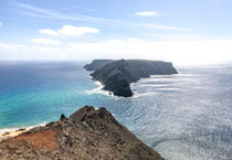
Top photo: View to Ilhéu de Baixo from Miradouro das Flores.
© A. van Roekel
Copyright: Annemieke van Roekel
Last update: July 25, 2022
|